

Data from Nisar offers new way to track soil moisture
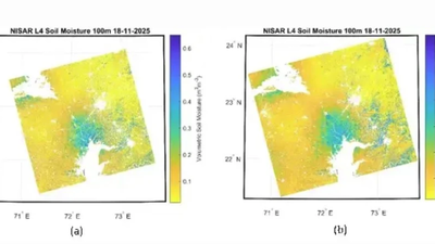

BENGLURU: The Nasa-Isro Synthetic Aperture Radar (Nisar) is now systematically scanning the Indian landmass, offering a new way to track one of agriculture’s most critical but invisible factors: soil moisture.Using advanced radar instruments operating in S- and L-bands, the satellite images the country every 12 days, covering wide swathes at high resolution. Scientists have demonstrated that this data can be converted into soil moisture maps at a fine scale of 100 metres. For a country where farming remains closely tied to the monsoon, that level of detail could prove significant.“Soil moisture is a key indicator of crop health, irrigation needs and drought risk. Until now, large-scale monitoring has relied heavily on weather data and limited ground stations. With Nisar’s radar-based approach, moisture levels can be assessed consistently across India’s varied landscapes, from irrigated tracts in the north to rainfed farms in central India and semi-arid belts in the west,” Isro said.The retrieval algorithm powering these products has been developed by Isro’s Space Applications Centre (SAC). Scientists say the physics-based model ensures that the estimates are scientifically robust and suitable for operational use.“Initial demonstrations show distinct patterns across agro-climatic regions. In western India, semi-arid areas display clear moisture stress. In the Indo-Gangetic plains of northern India, irrigation-driven variations are visible. Central India’s rainfed zones reflect rainfall-dependent wetness patterns. Together, these results suggest that the system can capture both large-scale trends and local variability,” Isro said.One of Nisar’s strengths lies in its dual-frequency design. The L-band radar can penetrate vegetation and crop cover more effectively, offering insight into moisture below the surface layer. The S-band, meanwhile, provides greater sensitivity to surface conditions and finer spatial detail. Scientists believe that combining both frequencies will improve reliability across diverse cropping systems.To support national operations, 100-metre Level-4 soil moisture products will be generated routinely at Isro’s National Remote Sensing Centre (NRSC). These will be disseminated through the Bhoonidhi Portal, making the information accessible to farmers, planners, researchers, government agencies and non-government entities.Each 12-day cycle will provide two observations, enabling near-real-time tracking of changing soil conditions. Such frequent monitoring could strengthen irrigation planning, drought preparedness and agrometeorological advisories at district and community scales.“Before full operational deployment, the products are being evaluated at calibration and validation sites across India. Ground-based soil moisture sensors are being used to verify and refine satellite estimates under different soil types, rainfall regimes and cropping systems,” Isro said.It added that further work is under way to develop even finer field-scale products that can capture moisture variations within individual farms. If successful at scale, Nisar’s soil moisture maps could become a core tool in data-driven agriculture, linking space-based observation directly to decisions taken in fields across the country.